Camaraderie... Good Shipmates... The Corinthians Way!
Corinthians Annual Cruise 2025: Maine
  • © 2025 The Corinthians 0

Corinthians Annual Cruise 2025: Maine

Stacks Image 51

 
Day 10; Saturday; 9 August 2025
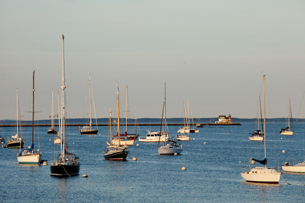
Camden, Maine

Almanac
Port of CallDayDateSunriseSunsetMoonrise
Camden98-Aug-25053319492017
Camden109-Aug-25053419482039
Tides
Reference Station:Pulpit Harbor
Port of CallDayDateDay of the WeekTime (LST/LDT)Predicted (ft)High/Low
Camden98-Aug-25Fri4:570.33L
Camden98-Aug-25Fri11:089.25H
Camden98-Aug-25Fri16:581.17L
Camden98-Aug-25Fri23:1110.8H
Camden109-Aug-25Sat5:37-0.06L
Camden109-Aug-25Sat11:479.72H
Camden109-Aug-25Sat17:410.73L
Camden109-Aug-25Sat23:5211.1H


Port of Call Latitude & Longitude:  44º 12.15 N; 69º 02.70
Order of the Day
·      See Table:  Order of the Day.
 
Introduction
·      Today is the 10th day of the Annual Cruise and the Cruise Finale!
·      The main events of the day are the Finale Cocktail Hour, Dinner, Awards Presentation.
·      Enjoy a relaxing day exploring Camden.  There are a myriad of shops, boutiques, and art galleries to provide plenty of retail relaxation exercise.
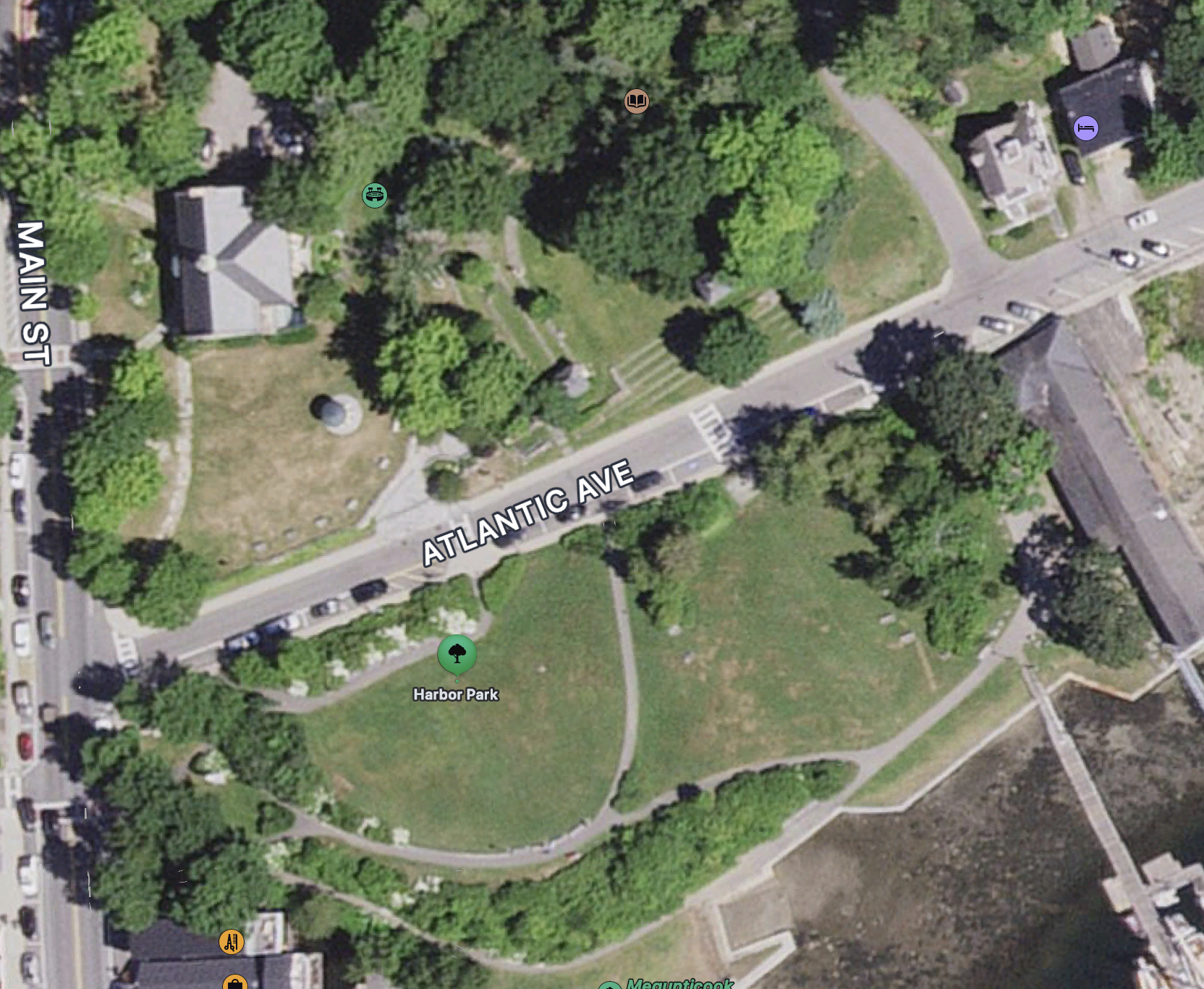
·      The Camden Yacht Club is located a short walk from the dinghy dock near the waterfall at the head of the harbor.  Just follow the W shore waterfront.
 
Port Captain(s)
·      Bill Burnham
 
Approach
·      Relax – the Fleet is not moving today!  So enjoy a lazy morning.  Then follow it up with a tasty lunch ashore.
Marinas; Moorings: Anchorage
·      See Table of Marinas, Moorings, Anchorages.
·      See Table of Marine Services.
·      Anchorage:  Very limited anchorage space in deeper water at harbor entrance – tends to be very rolly due to traffic and weather
·      Launch Service:  Lyman Morse
·      Dinghy Dock:  City pier at NW corner of harbor.  Be respectful use designated dinghy pier.
·      Fuel:  Lyman Morse Wayfarer Marina.
·      Water:  Lyman Morse Wayfarer Marina,  Camden YC for guests, City pier.
·      Pumpout:  Pumpout boat available.  Call VHF-
 
Provisioning
·      See Table of Provisioning Opportunities.
·      There is a Hannaford supermarket in Bar Harbor close to the Village Green.  Take the Island Explorer to the Village Green to explore Bar Harbor and finish the visit by shopping before taking the Explorer back to HR Able YY.
 
Restaurants & Libations
·      See Table:  Restaurant & Libation Opportunities.

Attractions & Activities

·      See Table:  Attractions & Activities.
 
Communications
·      Harbormaster:  VHF Ch-16
·      US Coast Guard:  VHF Ch-16
·      Corinthians Cruise Communications:
o   VHF Ch-?
o   Website:  corinthianscruise.org/BreakingNews
 
Camaraderie
·      A principal focus of today will be to say “Until” to Corinthians shipmates.
 
Fun & Games
·       
 
Racing
·      See Table:  Racing Activities.
·      No racing today!
·      Awards for Race performance will be presented at the Finale dinner at Camden Yacht Club.
 
References & Links


Rockland Boat Show

Hello, from Sea Eau

It is about 20 minutes car ride from Camden (about $25 uber):
https://maineboats.com/boatshow

Or 8nm from Camden, see:
Arriving by Boat
2014ComeByBoat
Welcome to Rockland! Rockland is a full-service destination for boaters. It boasts a long maritime history and a wonderful small-city ambience, much of which focuses around the harbor. Services are plentiful and conveniently located, and a variety of marinas cater to recreational craft of all sizes and shapes. The working waterfront remains, with plenty of fishermen and workboat skippers still using the wharfs, and the passenger schooner fleet is thriving.
Services abound for boaters:  More than 100 rental moorings / Dockage for vessels up to 250 feet / Pumpout services / Full-service boatyards (see list below) / Parts and marine supplies / Fuel, ice, laundry
Within easy walking distance of the harbor: Provisions, groceries, fresh seafood / Drugstore / Restaurants and pubs / Movie theater, live events, museums, galleries / Shopping / Pet supplies (even a dog wash!) / Day spas and barbershops / Library / Post Office / Banking & ATMs
Charts: NOAA chart 13302, "Penobscot Bay and Approaches,"or Maptech Waterproof Chart #40, "Rockland to Mount Desert Island" ?
Rockland Harbormaster: 207-594-0312 | VHF Channel 16 | www.rocklandharbor.info Official address: 1 Harbor Park, Rockland, ME 04841 Mailing address: 270 Pleasant Street, Rockland, ME 04841
The Harbormaster operates the Public Landing and can help with information and advice on moorings in Rockland Harbor. The harbormaster’s office is located at the Rockland Public Landing, at the foot of Harbor Park. Open year round, 8AM to 4PM Monday through Thursday. In the summer it’s open at least those hours seven days a week. They enjoy visitors but may be out of the office (on the water, running errands, up at city hall, or working on floats and maintenance). If it’s important, we advise calling before stopping in.
Launch Services:
  • Rockland Yacht Club Launch: 8 a.m.-8 p.m. / VHF Channel 9 / 207-233-2800
  • Two Toots: VHF Channel 9 / 207-594-2891
Local services: This is a boating community, so boat supplies, repairs of all kinds, and crew amenities are readily available.
Boat Parts & Supplies: Hamilton Marine: 20 Park Drive, Rockland, ME 04841 / 207-594-8181 Summer Hours (April - August): Monday-Friday, 7 am-6 pm / Saturday, 8 am-5 pm / Sunday 9 am-4 pm. Winter Hours (September - March): Monday-Friday, 7 am-5 pm/ Saturday, 8 am-5 pm / Closed Sunday. www.hamiltonmarine.com
Rockland Boatyards & Marinas:
Navigation and Hazards: Charts: NOAA chart 13302, "Penobscot Bay and Approaches,"?or Maptech Waterproof Chart #40, "Rockland to Mount Desert Island"
One of the busiest harbors in Penobscot Bay, Rockland sits on the west shore of West Penobscot Bay between Owls Head to the south and Jameson Point to the north. The breakwater extends from Jameson Point, with Rockland Breakwater Light showing from a red brick tower and building at the end of the breakwater. A fog signal is also located at the light.
Approaches: The most prominent objects are a radio tower, which is lighted at night, the aerolight at the Knox County Regional Airport, and the radio tower and signal mast at Rockland Coast Guard Station on Crockett Point. The light on Owls Head, the tower at the Dragon Cement plant in nearby Thomaston, and the light at the end of the breakwater are also conspicuous. Approaching Rockland Harbor, the Breakwater Light may be steered for on any safe course, using the chart as a guide. Enter the harbor southward of the breakwater light, giving it a berth of 100 yards or more. The approach channel has three branch channels, all buoyed.
Hazards: The southwestern side of the harbor is very shoal inside the line between Seal Ledge and Atlantic Point (where grain silos are located). The northernmost area of the harbor is also shoal inside a line between Jameson Point and the North End Shipyard (1 foot at mean low water). Several rocks and ledges are in the harbor. The visible ones are Shag Rock, on a cluster of bare rocks, 0.3 mile northwestward of Owls Head and marked by a day beacon; Lowell Ledge, a cluster of rocks awash at low water on the south shore of the harbor opposite Jameson Point; and Seal Ledge, which uncovers about 5 feet, in the southwest end of the bay and marked by a day beacon. A buoy marks Spears Rock, covered 5 feet, about 300 yards northeastward of Lowell Ledge. Dangerous wrecks are on the south side of the harbor entrance about 0.5 mile northeast of Spears Rock and in the southwest part of the harbor about 200 yards south of Seal Ledge.
Tides: The mean range of tide is 9.7 feet.
Good to Know: Shoreside and Emergency Services:
  • Airport: Knox Co. Regional, Owls Head 207-596-0617
  • Coast Guard: Rockland 207-596-6667 or VHF 16
  • Harbormaster: Rockland 207-594-0312
  • Police, Fire, Ambulance: 911

--
Smooth Sailing, 

Yossi cell 407-619-8227

Cécile cell 240-678-6355

Updated: 28 June 2025